Mt. Lola Tour


This is a greatly extended variation on everybody's favorite Peter Grubb Hut tour. Start the tour by parking at the Donner Summit/ Castle Peak Sno-Park parking area (a Sno-Park permit is required; 916-653-8569), just east of Boreal Ski Area, on the south side of I-80's Castle Peak exit (this Sno-Park sometimes fills fast, so get there early; the hotel near the Sno-Park sells Sno-Park permits; don't park at Boreal, or at the Donner Pass Rest Area). Then walk under the freeway to its north side right at the Castle Peak offramp. The tour begins here. Oh, if you're using the Donner Pass 15' quad, I-80 isn't shown! The trailhead is roughly a mile west of those lakes at "Euer Saddle".

  Heather at White Rock Lake
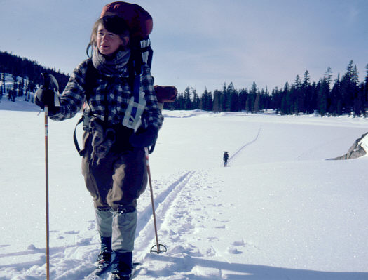
Heather Shepherd at White Rock Lake
Follow everybody else's ski tracks about 2 miles to the crest of Andesite Ridge, then follow the top of that ridge towards Castle Peak for about a quarter mile. Leave the ridge, traversing west of north into Round Valley, right smack in the middle of the Donner Pass 15' quad, where the Sierra Club's Peter Grubb Hut is located. Sierra Club members can reserve space in the Grubb Hut. Practically speaking, though, reservations are hard to get for Saturday night, and are pretty much unnecessary for other nights. Whether you sleep in or out of the cabin, you will need a winter-worthy sleeping bag; bring a pad and a tent along just in case the cabin is full (or in case you can't find it).

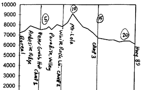
After a pleasant night at the Grubb Hut, ski northwards along the west side of Basin Peak towards, and then down into, Paradise Valley. From there, head northwest, and then northeast to the next camp, White Rock Lake.

The next morning brings us to the summit of Mt. Lola. I don't know how it'll be for you, but it was extremely windy when I was last up there. One variation of this tour would be to turn back the way you came, eventually returning to I-80 via the Grubb Hut. Or, you can stick with the program and enjoy a fun descent down the northeast bowl along Cold Stream. When you get to the flats along the Little Truckee River (campsite #3, if you like), ski eastward along the river. Turn left after about 2 or 3 miles, crossing over to the north side of the Little Truckee River. Note that the bridge which (according to the maps) is closest to the end of the tour no longer exists. So if in doubt, cross over to the north side of the river as soon as you can. Continue to ski eastward along the north side of the Little Truckee River about 2 miles to the "Little Truckee Summit" parking area on Hwy. 89 (15 miles north of I-80).

  (From the UCHC Trip Log)
Illustration from the original trip write-up in the UC Hiking Club Trip Log
I skied this route back in January 1984, with 7 others from the UC (Berkeley) Hiking Club (now called "CHAOS"). It was supposed to be a 3-day trip. Unfortunately, right around nightfall on the final day, the bridge that we expected to take across to Highway 89 turned out to not exist, making it a 4-day trip. (Using my ski poles for balance, I was able to ford the waist-deep Little Truckee, but the others didn't like the looks of it, so I had to ford back across and rejoin my pals on the wrong side of the river.)


 Previous Tour  Ski Tour Index  Next Tour

General info and disclaimer about backcountry skiing

Go to BobSkiing.com Home Page