| |
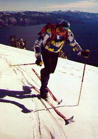
| Ken Ehlers above Lake Tahoe |
We found some fine slopes for cutting telemark turns on, though we couldn't quite do them justice since we had so far to go in one day. (Idea: a 3000'+ descent down the south rib of Rose Knob, ending up somewhere around Crystal Bay.) The tour was absolutely wonderful, at least until the last hour along the Martis Peak Snowmobile Highway anyway.
Considering how spectacular this tour is, there really isn't anything all that difficult on it. There are a handful of traverses across up-to-30-degree slopes, and some moderate 20-degree climbs and descents, but it was remarkable how consistently mellow the skiing was. We took 7 hours to do the 12-mile route. With firmer snow we could have made better time, but we wouldn't have wanted this one any other way than the conditions we had.
* * *
| |
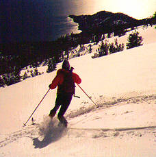
| Bob teles above Tahoe |
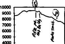
Continue along the ridge towards, and then around the south side of, 9600' Rose Knob. Soon after this, you will approach a big rock pinnacle on the ridge; that's probably Rifle Peak. Go around either side of this (we went around the south side). Just past there, we have a bit of a plateau, and the ridge splits NW and SW. Follow the SW ridge down to the unremarkable 9274' Mt. Baldy.
From Baldy, you need to turn to the northwest, following that ridge down through the trees to where it flattens out around 8400', east of Martis Peak. Drop down to around 8300' and contour around the south side of Martis. (Somewhere around here you'll probably pick up a well-worn snowmobile track to take you where you want to go.) Past Martis, just follow the popular snowmobile trail downhill to the trailhead.
General info and disclaimer about backcountry skiing