The Sierra High Route
- Advanced mountain terrain with some steep passes (up to 35 degrees or so)
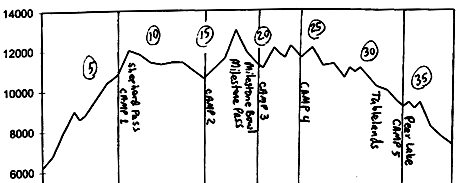
- 38 miles in 5 to 8 days
- Cumulative gain, loss: +12100', -11000'
- Avg. Relief: 600'/mile
- Topos: Triple Divide Pk., Mt. Whitney (15'); Lodgepole, Triple Divide Pk., Mt. Brewer, Mt. Williamson, Mt. Kaweah (7.5')
This classic tour was pioneered by Dave and Susan Beck. The Becks envisioned this line across the
southern Sierra as California's answer to the famous Haute Route of the Alps. This
tour is best done east-to-west, since so much of the climb east of the Sierra Crest
typically lacks snowcover by the spring season, when this tour is best done (average
tour elevation is 10400').
| |

|
|
Milestone Pass (in the upper right corner)
|
When I skied this route, in April 1986, it was a revelation to me. The trip had its ups and
downs, including a injury on the first day (someone went out with him; his cut hand ended up
being OK), a windstorm followed by significant snowfall in the Milestone area (resulting in
some wonderful powder skiing the next day), a sub-zero night, pass after pass that looked
insanely steep until we actually got close, and the full range of fine touring, turning,
mountaineering, and adventure that this trek offers. I couldn't have anticipated just
how much I would experience that week.
The tour begins at the Shepherd Pass trailhead, on Symmes Creek, several miles
southwest of Independence. The tour ends at the Wolverton Trailhead, on the west
side of Sequoia National Park. Parking is available at both trailheads. The car
shuttle is truly epic, so consider creative transportation arrangements.
It is a 6000' climb from the eastern trailhead to the first pass, Shepherd Pass.
Most of this is hiking, not skiing. A good Camp 1 is at 10500' to 11000', above
"Anvil Camp".
Shepherd Pass is fairly steep on the east side, and most people will be comfortable
taking off their skis and post-holing up it, ice axe in hand. From Shepherd Pass,
ski westward, south of Diamond Mesa, and then a bit south of west. Cross to the
north of the Kern River Canyon, and navigate your way westward along Milestone
Creek into Milestone Canyon. Make Camp 2 around here.
Ascend Milestone Creek westward towards Midway Mtn., and then turn southwest to
Milestone Pass, a high pass just to the left (southeast) of fin-shaped Milestone
Mtn. This pass is best reached by staying high to the right (northwest), close to
Milestone Mtn. The southeast side of the notch is a little steep at first, but
most of Milestone Bowl is a very fine descent. Take Camp 3 in lower Milestone
Bowl. And if the snow's good, take a layover day and decorate those slopes with
some S-turns!
| |

|
|
John Entriken Near Triple Divide Peak
|
We called the next pass "Not As Steep As It Looks Pass", based on its
description in one of the books (Beck's?) that we were using. This isn't so much
a pass as a ridge, and it lies across the valley from Milestone Bowl, a little
under a mile south of Colby Pass. Top this ridge around 12000', and then contour
along southwest, towards Triple Divide Peak. Next, go over an easy pass, taking you
across to the north face of Triple Divide Peak. Continue to contour along,
close to the divide, past Glacier Lake, up and over Glacier Ridge, and across
the southern reaches of Deadman Canyon. Cross back over to the southern side of
the divide at an easy pass just south of Big Bird Peak. Camp 4.
Contour along to the south of the divide now, crossing the next ridge at around
11100', and aim for the fine gentle skiing of the Tablelands, towards Table
Meadows. Continue along at a leisurely pace to the Pear Lake Ski Hut, Camp 5.
On the final day, follow the Pear Lake ski route out to the Wolverton trailhead,
via Pear Lake and Heather Lake, an anticlimactic finale to a great ski tour.
Sierra High Route in a day, May 2005


General info and disclaimer about backcountry skiing
Go to BobSkiing.com Home Page