| |
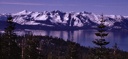
| The view towards Desolation Wilderness from South Camp Peak |
|
| |
| The view towards Desolation Wilderness from South Camp Peak |
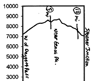
Starting elevation near Daggett is 7750', which is actually higher than Daggett Pass, and higher than the 7200' end of the tour at Spooner junction. Which is one reason why I suggest doing the tour in that direction (the other is that you'd rather be going downhill through the Spooner end of the tour, with its much greater snowmobile traffic). The tour's average elevation is a little over 8000'; it should be good in the winter months, losing some coverage at either end by early spring.
| |
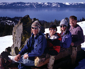
| Bob, Cathy, Sandra, and Jay, on the west-facing side of South Camp Peak |
From the Andria trailhead, follow what will probably be the dominant snowmobile route northward (or parallel the route on nearby hillsides). Soon after starting, the route zags to the left leading to a view of the lake; from there, you should gradually work your way up to around 8400' across generally Tahoe-facing slopes. About a mile southwest of Genoa Peak, you'll head over a gentle 8500' saddle. Continue north to the 8818' southern summit of the broad South Camp Peak, with its expansive views of Lake Tahoe. Continue from there to the north, and then eastward to South Camp's true summit, with its 8866' views of Carson City.
Drop into one of the east-facing bowls, descending 600' on wide-open slopes, before resuming travel on groomed snowmobile trails. Back on the groomed route, you'll go northwest and then north to the western base of Duane Bliss Peak, and then drop towards the northwest to the Spooner junction area, the tour ending at the snowmobile center just to the southwest of the highway junction.
Parking (free and plentiful) at the Spooner end of the tour is at the snowplay area along the Lake Tahoe side of the highway junction (the entrance is north of the junction). This is not far from the Spooner Lake XC center trailhead used by the next tour.
There's a more significant separation, however, if you want to connect this tour with Heavenly Valley, the previous "tour" in the series. It's 3 miles of pavement and development from the Andria trailhead of this tour to the Boulder Lodge entrance to Heavenly's "Nevada side" resort slopes (from Kingsbury Grade road, turn south onto South Benjamin). I think your choice there is to drive, or walk along the roads.
General info and disclaimer about backcountry skiing