Sonora to Sawtooth
- Varied mountain terrain including some fairly steep slopes (35 degrees or so)
- 37 miles in 4 to 6 days
- Cumulative gain, loss: +9900', -11300'
- Avg. Relief: 600'/mile
- Topos: Sonora Pass, Tower Pk., Matterhorn Pk. (15'); Sonora Pass, Emigrant Lk., Tower Pk.,
Buckeye Ridge, Matterhorn Pk. (7.5')

| |
|
|
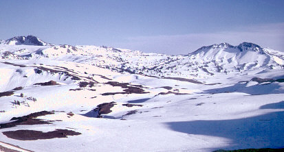
Mellow terrain approaching Grizzly Peak (on right)
|
Are you looking for a tour that is one big perfect tele-slope after another? Then don't do this
tour, go to the Ionian Basin instead. Now, for the few people still
reading this, particularly those of you who don't mind putting in some mileage, I can tell
you that this tour, Sonora to Sawtooth, is a real gem! The route offers variety, with
everything from gentle touring (particularly Day 2) to spectacular bowls (Days 3 and 5).
There is a variety of scenery as well: The gorgeous rolling terrain surrounding Grizzly Peak,
the sweeping glacial canyons of northern Yosemite NP, the wonderful cliffs and chutes from
Tower to Hawksbeak Peaks, the pretty little valley containing Robinson Lakes, and the stunning
terrain as you finally reach the Sawtooths.
Before I describe this tour, note that there is a slight gap between my
tour just to the north (which starts at Sonora Pass) and this one (which starts at
Leavitt Creek a few miles east of Sonora Pass). What should you do? Ski it of course!
A fine day tour, just after Sonora Pass opens, is to start at Sonora Pass, ski up the ridge
to the south, and ski the excellent east-facing bowl just to the north of Peak 11245'.
When you get to Sardine Meadow, ski a mile southeast to Leavitt Creek. Good job!
| |
|
|
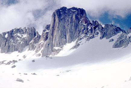
Tower Peak, and the bench along its northern side
|
Now, let's do Sonora to Sawtooth. This tour could be done in either direction, but I've
opted to describe it north-to-south because of the epic 4500' descent off of Sawtooth
Ridge at the southeast end of the tour. This stretch of the Sierra Crest tends to hold its
snowpack longer than most; its 9600' average elevation makes it fine for mid-to-late-spring.
You may want to wait until Hwy 108 is open, or at least open
on the east side to the starting trailhead, about 3.5 miles east of Sonora Pass (for the most
accurate information about exactly where the closure is, call the local Caltrans maintenance
station, 760-932-7261). But then, the starting trailhead isn't all that far from the winter road
closure at Leavitt Meadow.
Start by skiing up along Leavitt Creek from where you park along Sonora Pass
Road (the route leaves the highway at 8400'). Go to Leavitt Lake, and then head east of
south to attain the Sierra Crest. Traverse southward, staying east of the crest at the head
of Kennedy Canyon. Then cross over the crest, and contour around the headwaters of Kennedy
Creek. Head up the northeast bowl to just east of the summit of Peak 10824', then drop down
the bowl east of the peak's south side. This is a good place for Camp 1.
Day 2 is filled with the kind of mellow terrain that might lend itself to
waxless-patterned skis (or perhaps narrow skins). There are several options, all starting
from the above Camp 1:
- Take gentle terrain over to the west side of the crest at High Emigrant Lake, then
continue south around Grizzly Peak's west side. Turn southeast and follow the trail route
to Summit Meadow and Bond Pass. Descend into the Falls Creek drainage and head east over
Dorothy Lake to Dorothy Lake Pass.
- Go south and cross over to the west side of the crest just east of Grizzly Peak. Stay
high as you continue southward to Bond Pass. Drop down into Falls Creak drainage and go
east to Dorothy Lake Pass.
- Go south towards Grizzly Peak, then turn east to Grizzly Lake. From there, go southeast
to a bowl that breaks the wall about a half-mile west of Bonnie Lake. Descend to Stella Lake.
From the Dorothy Lake Pass and Stella Lake area, ski southeast to Lake Helen, Camp 2.
| |
|
|
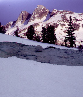
Evening colors in the upper Slide Canyon area
|
Take a nice pass from Lake Helen to Tower Lake, then ascend southward from Tower Lake to
the Sierra Crest overlooking Mary Lake. From the crest, turn east, then southeast, as you
ascend to the spectacular bench along the northeast base of Tower Peak.
Descend wonderful east-facing bowls, and traverse east to the base of the striking Hawksbeak
Peak. Turn southeast to cross the Sierra Crest yet again, at the top of Thompson Canyon,
a fine place for Camp 3.
Cross over to the east side of Thompson and traverse south to the 10100' pass that takes
you across to the top of Kerrick Meadow. Continue east to and across Peeler Lake. From
Peeler, proceed south of east to a little over 9800', and descend eastward into Robinson
Lakes. Proceed south to Crown Lake, and take a winding route, generally south and then east,
over 10450' Mule Pass. (An alternate route from Kerrick Meadow to Mule Pass is to go to lower
Kerrick, and ascend a bowl to the east, traversing around to Rock Island Pass. Get from Rock
Island to Mule via a traverse around 10300', or via the lower trail route.) Descend Mule
Pass generally via the trail route, east, then north, then east again, finally traversing
north to take Camp 4 in the bench area overlooking Slide Canyon, at 9900'.
There are two options for the final day:
- Perhaps the most expedient route is to pop over the crest to Ice Lake, and descend
Little Slide Canyon (if the lakes are too melted out to ski across, descend from the crest
to Ice Lake's outlet, then cross over to a side-gulley 1/4-mile east of Maltby Lake).
- However, a more fitting finale is to ascend 11569' (11581' on the older 15' topo)
Mt. Eocene. Start your ascent from Ice Lake, taking a gulley southeast up to 10900', then
turn northeast to get the rest of the way up. Take off those skins, shorten your poles,
and enjoy a long descent along Blacksmith Creek.
With both of the above options (particularly Little Slide), you should allow a couple
extra hours for possible low-canyon bushwhacking. The tour ends at the RV park at the west
end of Twin Lakes, where overnight parking is available for a fee.
* * *
One negative aspect of this tour is that much of the route, particularly the first half,
has gotten rather popular for illegal wilderness snowmobiling. Unfortunately, land managers are
not even a little serious about enforcing motorized access laws in the snow season, and the
sled-necks know it. For this reason, you might consider starting this tour mid-week.
Call or write the local Forest Service and
Park Service offices
and let them know what you think about their allowing such a wonderful natural area to
be turned into an arena for high-speed motorized thrills.
A snowmobiler responds to these comments about illegal wilderness snowmobiling.
An account of our 5/01 Sonora to Sawtooth trip, and more photos.


General info and disclaimer about backcountry skiing
Go to BobSkiing.com Home Page