| |
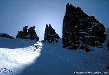
| Whitney Trail Crest, photo by George Bell |
Another option, if that road is closed, is to use the obscure Tuttle Creek trailhead, and to ascend the southern fork of Tuttle Creek to the Sierra Crest just north of Mt. Langley. This 6800' trailhead only gives a slight elevation advantage compared to the 6400' winter closure of the Horseshoe Meadow road; basically you'd be taking a steeper and more rugged route as an alternative to boring road hiking mileage. One big possible problem with the Tuttle Creek route, however, is that the final 1000' to the Sierra Crest is steep and may be subject to cornice hazard.
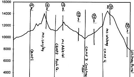
Let's put Camp 1 at Cottonwood Lakes, around 11000' and a few miles up Cottonwood Creek from the trailhead. If you had to hike up from the Horseshoe Meadow winter closure, you'll probably be taking Camp 1 on Cottonwood Creek at more like 10000'. Or, if you took the Tuttle Creek shortcut, try to make it up to 10500' or so.
Day 2 we do Mt. Langley. Pack up and pop over New Army Pass, roughly via the trail route. From New Army, forward march northward towards Langley, dropping your pack about a mile south of the summit at around 12400'. After checking out the summit, put the pack back on and descend west, along the southern base of The Major General. Traverse around Major G's west side and make Camp 2 somewhere in the upper reaches of Rock Creek. (If coming in via Tuttle Creek, reach the Sierra Crest north of Langley and ascend Langley via the ridge line; then descend south to join the described route around The Major General.)
Head west of north past Sky Blue Lake (consider a climb & descent of Mt. Pickering's north couloir while you're in the neighborhood), over Crabtree Pass just southwest of Mt. McAdie, and drop westward, past Crabtree Lakes, to Crabtree Meadow, Camp 3. Then ascend towards Mt. Whitney, doing Camp 4 near its southwestern base at 12000' or so.
You can ascend Whitney via the trail route to Trail Crest, or you can go more directly, via the slope that starts due west of Mt. Muir and goes northeast from there. After signing the book on Whitney and visiting Muir, travel southward west of the summit ridge (probably doing a lot of walking on the wind-blasted trail route) to Trail Crest. Descend from Trail Crest via a steep slope (unless the route's near-bare, it's probably best to not try to follow the hiking trail route) to the high campsite north of Consultation Lake, and then continue down to Whitney Portal via the trail.